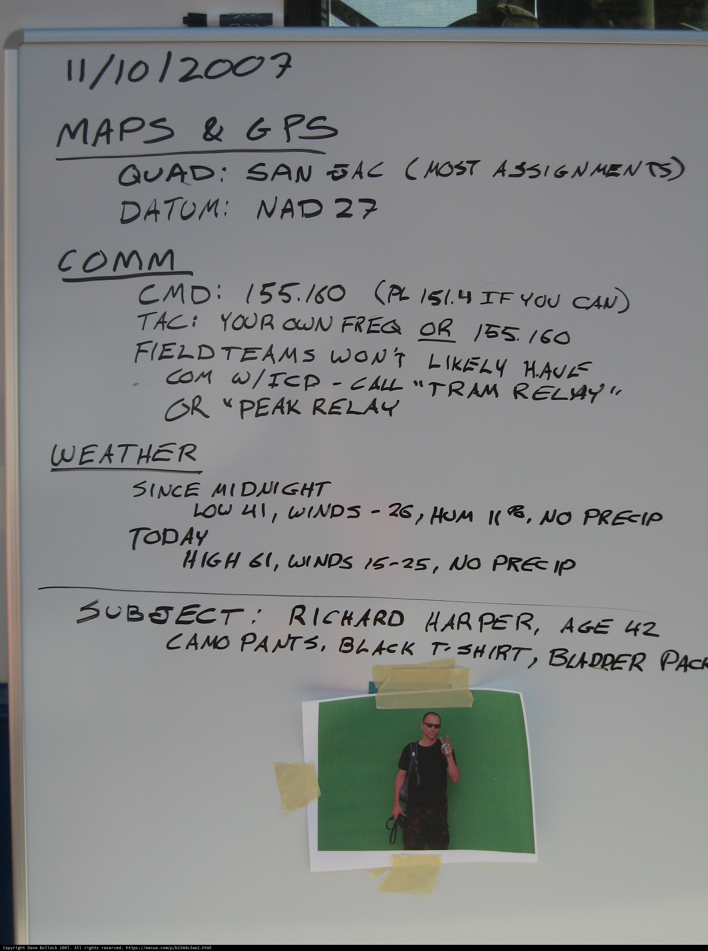
Photos | Mapping out the Martian Terrain
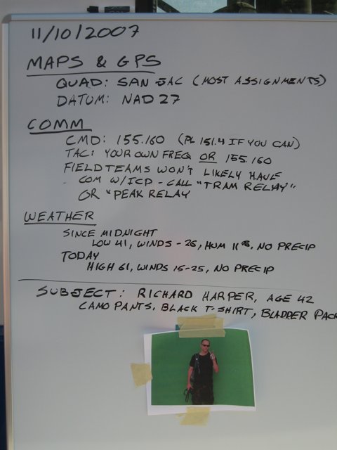
Two people strategize their GPS plan for exploring the Red Planet.
BLIP-2 Description:
a whiteboard with writing on it that says "mars b gps"Chronologically Adjacent
Note: You can also navigate with your arrow keys or swiping.
Metadata
Capture date:
Original Dimensions:
2304w x 3072h - (download 4k)
Usage
Dominant Color:
accessories blader midnight sal tram high handwriting richard tishirt today board datum black since peak presip harper precip gps menu san age cmd maps pants fieldteams relay pac camo comm freq tac no oun wont white low weather hum call winds document text glasses subject nad likely icp assignments pl quad
Detected Text
10 11 15 151.4 155.160 155.180 2007 25 26 27 41 42 61 assignments age b blader camo cmd comm call datum fieldteams freq gps harper hum i icp if likely low midnight maps nad pac peak pl precip presip quad relay richard sal san subject tishirt tram tac w winds black can com have high most no or oun pants since today weather wont you your
iso
50
metering mode
5
aperture
f/3.5
focal length
10mm
shutter speed
1/500s
camera make
Canon
camera model
lens model
overall
(3.41%)
curation
(25.00%)
highlight visibility
(1.99%)
behavioral
(10.20%)
failure
(-0.17%)
harmonious color
(0.94%)
immersiveness
(0.12%)
interaction
(1.00%)
interesting subject
(-85.50%)
intrusive object presence
(-5.13%)
lively color
(24.57%)
low light
(0.10%)
noise
(-0.37%)
pleasant camera tilt
(-6.10%)
pleasant composition
(-11.05%)
pleasant lighting
(-1.76%)
pleasant pattern
(3.15%)
pleasant perspective
(9.88%)
pleasant post processing
(2.37%)
pleasant reflection
(0.38%)
pleasant symmetry
(0.85%)
sharply focused subject
(2.27%)
tastefully blurred
(0.27%)
well chosen subject
(6.93%)
well framed subject
(29.10%)
well timed shot
(-3.27%)
all
(1.94%)
* WARNING: The title and caption of this image were generated with AI (gpt-3.5-turbo-0301
from
OpenAI) based on a
BLIP-2 image-to-text labeling, tags,
location,
people
and album metadata from the image and are
potentially inaccurate, often hilariously so. If you'd like me to adjust anything,
just reach out.